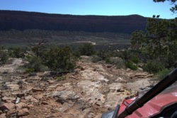
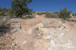
The weather is getting nice so went camping and riding in a spot in SE Utah known as Comb ridge:
From the interweb: Comb Ridge (Navajo: Tséyíkʼáán) is a linear north to south-trending monocline nearly 80 miles long in southeast Utah and northeast Arizona. Its northern end merges with the Abajo Mountains some eleven miles west of Blanding.
We camped just west of the ridge in Comb Wash (a BLM open camping area) off UT Hwy 95 to the west of Blanding, UT. Rode around the immediate area checking out the trails and some prehistoric Native American dwellings.
Here's a shot from the top of the ridge looking south at Hwy 95. In the wash below you can see the open BLM camping area.

Yup, there's our campsite.

Here's the view looking to the north.

So how do you get from the wash to the top of the ridge? One way is to take the original "highway". It's the shelf road cut diagonally across the sandstone rock face in the photo below.

Here's the upper part where it breaches the edge of the ridge.

Looking back down.

Another trail on the west side of the wash. Lots of slick rock in the area.


Besides some excellent trails there's also Native ruins everywhere!

Along with petroglyphs.

It would take weeks to explore this area. So we'll be back.
From the interweb: Comb Ridge (Navajo: Tséyíkʼáán) is a linear north to south-trending monocline nearly 80 miles long in southeast Utah and northeast Arizona. Its northern end merges with the Abajo Mountains some eleven miles west of Blanding.
We camped just west of the ridge in Comb Wash (a BLM open camping area) off UT Hwy 95 to the west of Blanding, UT. Rode around the immediate area checking out the trails and some prehistoric Native American dwellings.
Here's a shot from the top of the ridge looking south at Hwy 95. In the wash below you can see the open BLM camping area.
Yup, there's our campsite.
Here's the view looking to the north.
So how do you get from the wash to the top of the ridge? One way is to take the original "highway". It's the shelf road cut diagonally across the sandstone rock face in the photo below.
Here's the upper part where it breaches the edge of the ridge.
Looking back down.
Another trail on the west side of the wash. Lots of slick rock in the area.


Besides some excellent trails there's also Native ruins everywhere!
Along with petroglyphs.
It would take weeks to explore this area. So we'll be back.

