

Hondasxs
Club Founder
Staff member
Lifetime Member
Supporting Member
Review of DMRA trail system.
http://www.doemountain.org/
The past few years, we have tried to make it a yearly tradition to take a trip for the purpose of riding in snow. This made our third yearly to Mountain City to enjoy the white stuff. This year we had plans to try out the new Dow Mountain Recreational Area trails. Here is a basic review. Keep in mind, this is a new system and should be considered in the startup stages.
Upon arriving we found it difficult to find the entrance to the trail head as the building blinded in with the sounding houses. After reviewing the trail map and Google Maps, we finally noticed a small DMRA sign that showed us the entrance gate. We visited the welcome center and bought out day passes, $18 for the driver $3 for passengers. The Mountain City Mayor was there and he greeted us. We discussed the trail and were excited to hear future plans of allowing connector trial to the town to get food and gas.
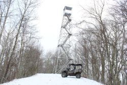
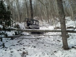
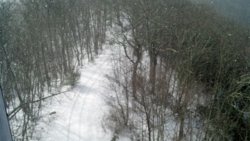
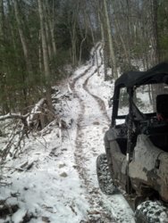
After unloading we headed down trail #1. Our first stop was the fire tower. It was closed to climb but ground level still allowed for a nice view of the city and mountains. Next we headed to trail 24, but it was for dirt bikes only. We then headed to 27. Here we found a long downhill decent. But it came to a screeching halt as the bottom exit was blocked by cut trees. The purposefully cut trees blocking the hill did not allow us an exit. Unable to turn our Side by Side around we were forced to reverse back up the hill until a spot large enough to turn around in was found. This was about 100+ yards up. Looking at the map you see 27 currently stop midways, we realized we had journeyed onto unmarked trails. However there was nothing informing us of this before the hill decent had begun. That morning I did say to myself. “do I need the chain saw”. But I chose to leave it.
After a break we headed to a spot marked Chimney Rock. But found it was a hiking trail. Next, we were off to 28. There we found the trail getting tight. Mostly because work is still being done to develop trails in this area. We continued as far as it would allow our 63” side by side to travel. We headed back up 28 and connected to 26. We traveled it all the way to the boundary gate and returned. Back down 26 we noticed several novelty signs designating cretin areas, we found this nice as naming sections will allow for better identifications of the areas. We saw: “Rest area”, “Truck stop”, “Boob Tree” and others.
Could not find the real picture, but it looked like this and had a neat little sign to point it out to you.
At the 26/24 intersection named “Bear crossing” we took the unmarked trail between 26 and 24 until it begun to get too tight for our SxS. We then headed back down 1 to 21. Somehow we ended up on the unmarked 21/23 midway connecter. Not knowing we were on 23 we road it to the right and ended up back to the 21 connector. According to the trail listing, Trail 23 is not open to OHV’s. however it was one of the smoothest trails we had ridden so far. Disobeying the map. We continued back down 23 until we came to a house and a gate where we then turned around. We were going to take the difficult red trail connecting 23 to 23 but decided to take the unmarked midway connecter back to 21.
Once back on 21 we headed back to the trail head. We were fixing to pack up but then decided to ride the power line a bit. We ended up riding the line all the way to the boundary line. We then hit 115 to 15. And glad we did. 15 turned out to be the best trail so far. It was technical and allowed us to ride the top of a ridge line. Once to 117 it was getting late. We decided to head back to the truck.
We did not have time to ride the following trails 10, 14, 116, 16, 20, 17, 112, 12, some of which may not open to OHV’s.
Heres a vid I was working on but we really didn't get too much usable footage, here it is anyways.
Trail suggestions, Just know this is a new system so alot of things will improve.
The map is one of the best drawn maps for any of the trail systems we have been on. It is accurate and true. We did find it difficult to quickly pick what trails allowed different methods of travel. Example: OHM, OHV, Horse, Bike, or Hike? As more trails get added this will be a difficult system to keep track of. Suggest a different alternative to identifying tails. Also, they should think of identifying the grid at a civilian level. For example: It is hard to locate block 81.51.15W/36.25.45E? Wouldn’t Block E9 be easier to locate?
27/23 connector is dangerous at this time. The danger is the blockage at one end, not the actual hill. This needs to be unblocked, or upper 27 needs to be blocked before the long decent begins.
Open up #23 to OHV’s. This was the smoothest trail of them all. It is a shame to have such a good trail closed to OHV’s.
#15 was the best trail, would like to seem more “actual trails” like this one!
Final take.
Overall system was very well mapped. Most trails were old fire ways or logging roads. Only trail 15 was a actual trail. System is set up for a good full day ride. Could spend a weekend trip here but any longer would leave me exploring areas I should not in hopes of finding a new trail. We will be returning? Sure, Keep in mind this is a new system and as the Mayor has given personal support for the project I cant wait for it to grow in the years to come.
http://www.doemountain.org/
The past few years, we have tried to make it a yearly tradition to take a trip for the purpose of riding in snow. This made our third yearly to Mountain City to enjoy the white stuff. This year we had plans to try out the new Dow Mountain Recreational Area trails. Here is a basic review. Keep in mind, this is a new system and should be considered in the startup stages.
Upon arriving we found it difficult to find the entrance to the trail head as the building blinded in with the sounding houses. After reviewing the trail map and Google Maps, we finally noticed a small DMRA sign that showed us the entrance gate. We visited the welcome center and bought out day passes, $18 for the driver $3 for passengers. The Mountain City Mayor was there and he greeted us. We discussed the trail and were excited to hear future plans of allowing connector trial to the town to get food and gas.
After unloading we headed down trail #1. Our first stop was the fire tower. It was closed to climb but ground level still allowed for a nice view of the city and mountains. Next we headed to trail 24, but it was for dirt bikes only. We then headed to 27. Here we found a long downhill decent. But it came to a screeching halt as the bottom exit was blocked by cut trees. The purposefully cut trees blocking the hill did not allow us an exit. Unable to turn our Side by Side around we were forced to reverse back up the hill until a spot large enough to turn around in was found. This was about 100+ yards up. Looking at the map you see 27 currently stop midways, we realized we had journeyed onto unmarked trails. However there was nothing informing us of this before the hill decent had begun. That morning I did say to myself. “do I need the chain saw”. But I chose to leave it.
After a break we headed to a spot marked Chimney Rock. But found it was a hiking trail. Next, we were off to 28. There we found the trail getting tight. Mostly because work is still being done to develop trails in this area. We continued as far as it would allow our 63” side by side to travel. We headed back up 28 and connected to 26. We traveled it all the way to the boundary gate and returned. Back down 26 we noticed several novelty signs designating cretin areas, we found this nice as naming sections will allow for better identifications of the areas. We saw: “Rest area”, “Truck stop”, “Boob Tree” and others.
Could not find the real picture, but it looked like this and had a neat little sign to point it out to you.
At the 26/24 intersection named “Bear crossing” we took the unmarked trail between 26 and 24 until it begun to get too tight for our SxS. We then headed back down 1 to 21. Somehow we ended up on the unmarked 21/23 midway connecter. Not knowing we were on 23 we road it to the right and ended up back to the 21 connector. According to the trail listing, Trail 23 is not open to OHV’s. however it was one of the smoothest trails we had ridden so far. Disobeying the map. We continued back down 23 until we came to a house and a gate where we then turned around. We were going to take the difficult red trail connecting 23 to 23 but decided to take the unmarked midway connecter back to 21.
Once back on 21 we headed back to the trail head. We were fixing to pack up but then decided to ride the power line a bit. We ended up riding the line all the way to the boundary line. We then hit 115 to 15. And glad we did. 15 turned out to be the best trail so far. It was technical and allowed us to ride the top of a ridge line. Once to 117 it was getting late. We decided to head back to the truck.
We did not have time to ride the following trails 10, 14, 116, 16, 20, 17, 112, 12, some of which may not open to OHV’s.
Heres a vid I was working on but we really didn't get too much usable footage, here it is anyways.
Trail suggestions, Just know this is a new system so alot of things will improve.
The map is one of the best drawn maps for any of the trail systems we have been on. It is accurate and true. We did find it difficult to quickly pick what trails allowed different methods of travel. Example: OHM, OHV, Horse, Bike, or Hike? As more trails get added this will be a difficult system to keep track of. Suggest a different alternative to identifying tails. Also, they should think of identifying the grid at a civilian level. For example: It is hard to locate block 81.51.15W/36.25.45E? Wouldn’t Block E9 be easier to locate?
27/23 connector is dangerous at this time. The danger is the blockage at one end, not the actual hill. This needs to be unblocked, or upper 27 needs to be blocked before the long decent begins.
Open up #23 to OHV’s. This was the smoothest trail of them all. It is a shame to have such a good trail closed to OHV’s.
#15 was the best trail, would like to seem more “actual trails” like this one!
Final take.
Overall system was very well mapped. Most trails were old fire ways or logging roads. Only trail 15 was a actual trail. System is set up for a good full day ride. Could spend a weekend trip here but any longer would leave me exploring areas I should not in hopes of finding a new trail. We will be returning? Sure, Keep in mind this is a new system and as the Mayor has given personal support for the project I cant wait for it to grow in the years to come.
![db2615-boob-tree[1].jpg](/data/attachments/0/699-0a8dd53461eec60e9f91535ee7cb5602.jpg)