The wife, son, dogs and I took the pioneer up north to Pittsburg, NH. We rented a cabin on Back Lake at Tall Timber’s Lodge. Nice little side story open arrival and departure, our cabin, Gramps, was one of two original cabins built on the lake. Front porch about 6’ from the lake.

This area of the state is the northern most section of the atv/utv trails that are a 65” width limit. The Ride the Wild corridors pass through providing destination riding to other towns. There are also local club trails on about 8000 acres of timber company land, that’s where we mostly stayed.
Off the trailer and ready to roll.

We arrived Thursday afternoon in the rain and trails close at dark so no riding the first day.
Friday was still raining but we stayed relatively dry with the roof, windshield and soft mid panels. I had brought the soft upper doors just in case, but we never needed them.
Mostly single track trails there were easy and some dirt roads.

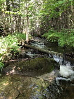
marked this spot for next time. Trout stream that originate a couple miles from the Canadian border.

The trails were well marked, I didn’t end up buying a paper map, but we had the tablet with Gaia and gpstrailmasters files and the coverage was 95% I would say. I’ll get some screen shot from the table this weekend. Trail maker.

Friday afternoon we went towards another stream and some dirt roads to cruise and out a few miles on. The boy was good for about 2 hrs before needing out.


Picnic area with a view. Marked on the Gaia map.

This area of the state is the northern most section of the atv/utv trails that are a 65” width limit. The Ride the Wild corridors pass through providing destination riding to other towns. There are also local club trails on about 8000 acres of timber company land, that’s where we mostly stayed.
Off the trailer and ready to roll.
We arrived Thursday afternoon in the rain and trails close at dark so no riding the first day.
Friday was still raining but we stayed relatively dry with the roof, windshield and soft mid panels. I had brought the soft upper doors just in case, but we never needed them.
Mostly single track trails there were easy and some dirt roads.
marked this spot for next time. Trout stream that originate a couple miles from the Canadian border.
The trails were well marked, I didn’t end up buying a paper map, but we had the tablet with Gaia and gpstrailmasters files and the coverage was 95% I would say. I’ll get some screen shot from the table this weekend. Trail maker.
Friday afternoon we went towards another stream and some dirt roads to cruise and out a few miles on. The boy was good for about 2 hrs before needing out.
Picnic area with a view. Marked on the Gaia map.


