Have you been to Namadgi. Just a little north .
Nemadji State Forest is roughly 30 miles south of Duluth, so may not qualify as "southern MN" to folks who don't live in the Northwest Angle (north of Lake of the Woods). It is a decent place to ride, with some winding trails and a few gentle hills. Most trails are posted for ATV Class I and II, implying a 65" limit on vehicle width, but I don't recall any physical gates even close to 65". A (very) few trails are posted as Class I (50" limit). I didn't ride any Class I trails, but these may be gated by the trees.
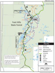
If you're going that far north (or south, to those Angle people), Spider Lake Trails, in the Foot Hills State Forest, is more winding and less flat than Nemadji. SLT is roughly 40 miles northwest of Brainerd MN. One hill has a 35% grade (that was this spring, will vary, of course, with erosion). See attached(?) map. Most hills are 20-25% grade. There's also a makeshift ATV playground (or two) at the northeast corner of the trail system, just south of 24th St. The trails are fun (especially the one short one-way trail), but don't expect a lot of breath-taking scenery. Not many, if any, width-limiting gates, but a 65" Pioneer roll cage is tight around some of the trees. Two forest toilets at roughly opposing ends. The state DNR offers a geo-PDF. The map says there's two parking lots, but the one at the southwest end might hold one rig. There are numerous campsites scattered about the trails. None of the trails have names nor numbers (other than the forest roads), but some intersections are numbered. I've got crude gpx tracks, message me if you want them.

Further south, and further east, is Chippewa County Forest in WI, about 20 mile northeast of Chippewa Falls. Small (20-some miles of trail), but very nice, if you're not a fan of abandoned railroad beds, but don't want any threat of needing a winch. 65" max. width, but the gate tolerance is more generous than what I've seen around Barron County WI (a 68" Talon would sneek in here). There's several hills with signs labelled "steep hill" which, in this case, means up to 20% grade (i.e. not steep). If you go around once clockwise, and again counter-clockwise, and stop for some pics at the lakes and streams, you could burn 4 to 5 hours easily. There's two spurs that could add an hour or more to your ride time. There are two forest toilets at (approximately) opposing ends. Two small (6-7 rigs) parking lots at (roughly) opposing ends. Usually open till 15 Nov. I've got crude gpx tracks, message me if you want them (there's only about four turns that you could possibly miss).