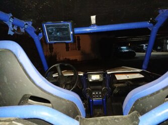
P1000 Thinking on using my iPad mini for navigation?

Remington

Remington

POIDH Enforcement Officer
Lifetime Member
Supporting Member
Jul 24, 2016
20,253
115,818
113
Michigan
Ownership

  1. 1000-5

  2. Talon X
Oh boy……. 😂

once again, use the search at the top right corner. This subject has been beat so hard there still marks where the jockey was hittin!
 
Scoop

Scoop

Well-Known Member
Lifetime Member
Supporting Member
Sep 7, 2021
5,191
20,510
113
Michigan
Ownership

  1. Other Brand

  2. 1000-5

  3. Talon R LV
IIRC, the Wifi-only versions of the EyePad don't have a GPS chip, while the WiFi + Cellular models do.

You want something with a GPS chip so you can use it even when you don't have cellular service.

Samsung Galaxy Tab A7 10.4" Wi-Fi Tablet 64GB and a RAM Mount setup running OruxMaps and VVMapping.

1642112527331
 
StewB

StewB

Well-Known Member
Jan 2, 2021
731
3,398
93
Utah
Ownership

  1. 1000-5
Those waterproof?
Ride Command?

Just messing with you - I've used an iPhone with:
- Trimble Outdoor Navigator (excellent, steep learning curve and discontinued).
- Gaia Pro (not bad, but moved on).
- Avenza Maps Pro (I'm still getting used to this, but there are tons of map options).

Utah has quite a checkerboard of federal, state and private parcels. Where Trimble rocked was in dealing with public / private land - they had a great layer showing land status that would overlay offline (stored) aerials, topos, and other maps.
With Avenza, you have to make sure the map you download has the info built into the geo-referenced pdf.

Scoop is right about the iPad - has to have cellular to catch a GPS signal.
 
Last edited:
StewB

StewB

Well-Known Member
Jan 2, 2021
731
3,398
93
Utah
Ownership

  1. 1000-5
GAIA GPS app on iPad Air II drew this 1500 mile ride - (9.5" diagonal screen). I add the red pins as I go (or beforehand if I want to find something) and the app saves photo locations (blue circles).
View attachment 313377
Super cool. Been through some of that country as well. The Wedge, Factory Butte, and know about the closed roads in Mexican Mountain WSA. Are Temple Mountain and Black Dragon on your photo points?
 
CID

CID

Well-Known Member
Lifetime Member
Supporting Member
Oct 27, 2019
5,487
25,252
113
SE Denver-ish
Ownership

  1. Talon R
Super cool. Been through some of that country as well. The Wedge, Factory Butte, and know about the closed roads in Mexican Mountain WSA. Are Temple Mountain and Black Dragon on your photo points?
Cool. Short story - In 2018 I drove 38,295 miles across the USA and Canada, it took me 7 months. When I got back someone asked - "Now that you've been everywhere, where's your favorite place." Without hesitation - "Southern Utah" and I knew that before I left. 😍

The bottom center pic icon is indeed by Temple Mountain. I don't take all my pics with GAIA, maybe I should, there are many more. The lower, far right track in red, is Black Dragon, one of my favorites but no GAIA photo there in that screen shot.

The purple track in the top right is The Wedge loop, and at 145 miles, was my longest day ride and I almost ran out of fuel (not counting the Rotopax). That included the 30 mile Mexican Mountain out-n-back spur. Every time I make that ride, I'm saddened that it's gated closed. Part of that loop was Fix It Pass. :oops:

This pic was taken on the way out of Mexican Mountain - (sorry, intended these to be thumbnails 😊 )
FZYX7646


Factory Butte from the south -
IMG 7650


Factory Butte from the NW (far left) -
IMG 7472
 
advertisement
W

Walterr

New Member
May 26, 2021
8
21
3
Orem, UT
Ownership

  1. 700-4
I like iHikeGPS on the iPad for this sort of thing. It primarily just shows TOPO maps of wherever you are. The idea being you download the maps you are going to want at the scale you desire ahead of time. Down to USGS 7.5' TOPO Quads if you like. Then it tiles them seamlessly. Takes some setup before you go, but well worth it to me as that part is fun also. I grew up pouring over the paper versions, so this matches well for me. iHikeGPS - USA Topo Maps on your iPhone, iPad, and iPod touch

Been going to Black Dragon canyon since before I can remember.

I also have a Bad Elf GPS dongle. Works well to add location to a wifi only iPad.
 
G

grizzly660fan

Member
Jul 17, 2017
50
86
18
Utah
Ownership

  1. 1000-5
I had an old Samsung 8" tablet that I use for mapping in my 1000-5, I got a rugged (but not waterproof) case for it and put velcro on the large safety message in the center of the dash where a lot of other people convert into a switch panel and on the back of the tablet case, its an easy access to the 12 volt cigarette connection to keep the tablet charged and it has worked extremely well in that location since 2017 for me. Also the tablet is almost the exact size of that safety message almost like it was designed to fit there.

I have been out in rain and snow storms and have a tip up windshield but have never gotten the tablet wet. I do get a fair amount of dust on the tablet but that wipes away easily after each ride.

I prefer Avenza for my mapping software.

I guess my comment is if you get the correct tablet with a GPS chip in it your idea will work very well.
 
B

boOkerT

Well-Known Member
Apr 20, 2021
250
1,072
93
Bellingham, Washington
Ownership

  1. 1000-5
Thinking I might add the iHike like Walterr uses and upgrade my iPhone to the iPhone max then won't be leaving anything mounted in the SXS for easy pickings.
 
  • Like
Reactions: Lady01 and Farmer
P1K5Dave

P1K5Dave

Well-Known Member
Lifetime Member
Club Contributor
Jul 11, 2020
2,258
8,457
113
Petoskey, MI
Ownership

  1. 1000-5
OsmAnd is the best mapping app, if you've got a geekier side to you.
 
  • Like
Reactions: Lady01
M

Mickey308

New Member
Dec 31, 2016
3
12
3
Montana
Ownership

  1. 500
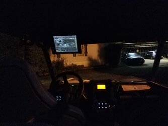
Curious if anyone has set up a navigation system onboard using an tablet and and if so what was needed? Was thinking on using Xhunt or somthing similar......
Don't make it to complicated. Load onX on your phone. Works great
 
  • Like
Reactions: Lady01
HUCK

HUCK

Well-Known Member
Lifetime Member
Jun 21, 2016
1,047
2,319
113
ARIZONA
Ownership

  1. 500

  2. Talon X
I use a Samsung tablet and sometimes my iphone with GAIA and the Samsung Galaxy Tab A with Android works better than the iphone as far as GPS .
 
A

a94cobra

Member
Dec 28, 2021
44
96
18
TX
Ownership

  1. Talon X LV
Ipad. with a RAM Mount. If you get a cellular model it has GPS. Even if you don't subscribe to service.

Using On X Offroad(free version). If you know where your going that day, you can download a map for offline use when you have wifi. Tracks pretty good.

I havn't used the other progs to see the differences. What does everyone recommend?

I put it there to help block the sun and to help see it in the daylight.

IMG 20210623 215317 IMG 20210623 215310
 
  • Like
Reactions: Lady01 and StewB
advertisement

About us

  • Our community has been around for many years and pride ourselves on offering unbiased, critical discussion among people of all different backgrounds. We are working every day to make sure our community is one of the best.

User Menu

Buy us a beer!

  • Lots of time and money has gone into making sure the community is running the best software, best designs, and all the other bells and whistles. Care to buy us a beer? We'd really appreciate it!

    Beer Fund!

    Club Membership!