Prntckt
Well-Known Member
Lifetime Member
Got a first trip to Colorado coming up in a few weeks.
What do guys recommend for apps/maps for the Lake City area?
What do guys recommend for apps/maps for the Lake City area?

'Close' is a relative term, no? 🤣I realize I’m not even close to CO but thought I would mention it.
Thanks! I loaded up Gaia on my tablet and started to play with it. Looks like it should do the job. I have been using a midwest specific map system from VV Maps that runs on Orux maps. It works well in my home area, but doesnt support Colorado at all.I went in blind, it's my go-to navigation system. That said - I kept track of where I was with GAIA GPS on my iPad. Once I got GAIA, I just look for dotted white lines. GAIA is free, btw. I'm paying $29 a year because I wanted the 'forever' track logs, like below. They may be free too, but I signed up before finding out.
Lake City is very UTV friendly and there are maps available everywhere. That doesn't help if you want to study up before you leave though.
GAIA screen shot, blue track is where I've ridden, dotted white is where I haven't.
View attachment 350220
My tablet does have GPS onboard, so thats another option to consider. I have been following San Juan Mountain trail Facebook group for awhile now. Ive been thru the cooling system bleed process as I installed a heater in my pioneer the first winter that I had it. No fan over ride, though. Might have to order one up quick from the club store….all good suggestions, thanks.Cotrex app is Colorado state sponsored and free download if your tablet has GPS it will follow you all through the trails, also could just download san Juan mountain mvum map from forest service and does similar. Another excellent resource if you do Facebook is San Juan Mountain trail group . Really great riding that area. Make SURE you have read up on cooling system bleed procedure and have fan override switch installed prior are my best advice!
GAIA uses several common topo databases including the USGS topo so it should be good nationwide. I haven't learned how to download maps and much of my riding is out of signal but it still seems to work. Having your choice of topo downloaded into the tablet would be a good idea.Thanks! I loaded up Gaia on my tablet and started to play with it. Looks like it should do the job. I have been using a midwest specific map system from VV Maps that runs on Orux maps. It works well in my home area, but doesnt support Colorado at all.
The fan override covers a multitude of potential problems. Heck, I added one to my V-Max because they tend to run hot in traffic.My tablet does have GPS onboard, so thats another option to consider. I have been following San Juan Mountain trail Facebook group for awhile now. Ive been thru the cooling system bleed process as I installed a heater in my pioneer the first winter that I had it. No fan over ride, though. Might have to order one up quick from the club store….all good suggestions, thanks.
I bought the fourth edition of Guide to Colorado Backroads &4 Wheel Drive Trails. Looks like it has most if not all of the popular trails in the Lake City area.Buy the books that are avalible! Very informative. And really cheap for the info included.
You sold me, fan override kit is now on order from the club storeThe fan override covers a multitude of potential problems. Heck, I added one to my V-Max because they tend to run hot in traffic.
It’s great when it’s cool out too. Turn it on to blast some heat at ya!You sold me, fan override kit is now on order from the club store
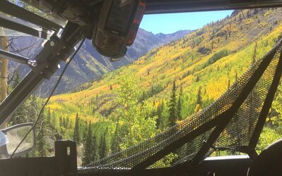
I was in Lake City last year Sept. 19 - 25, the weather was perfect and the aspen were in full boogie. I agree, with altitudes above 12,000 feet, always have winter wear available. 👍In a few weeks may be a bit late. Was there in Silverton second week of September in '18 and snow had already started to fall some and had ice on buggy early in the morning. Carry cold weather gear for sure!

Beautiful scenery at that time to experience if the weather cooperates! Good luck and hope it does! Wish we could be there!I was in Lake City last year Sept. 19 - 25, the weather was perfect and the aspen were in full boogie. I agree, with altitudes above 12,000 feet, always have winter wear available. 👍
View attachment 351374
Yes LTMap covers that area.Lifetime trail map is the best on the east coast. I’m not sure if it would be good out west.

