OsmAnd for Mapping and Navigating: A Guide

P1K5Dave

P1K5Dave

Well-Known Member
Lifetime Member
Club Contributor
Jul 11, 2020
2,260
8,463
113
Petoskey, MI
Ownership

  1. 1000-5
Upon further review, I can't find anything else talking about any West trails. Every source I look at only shows what we've mapped here.


And I now see that the "trail" set is for 50" and under, while the "route" set would be for full-size machines. In that case, I would not use the combined file. I'd load the two separately and give them different colors.
 
  • Like
Reactions: Robobrainiac
P1K5Dave

P1K5Dave

Well-Known Member
Lifetime Member
Club Contributor
Jul 11, 2020
2,260
8,463
113
Petoskey, MI
Ownership

  1. 1000-5
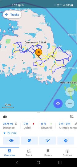
Here it is. I loaded them separately and made the wider trails blue and thicker, narrow trails are red and thinner.

Screenshot 20220418 084419
 

Attachments

  • dir.gpx
    517.8 KB · Views: 118
  • dit.gpx
    504.3 KB · Views: 120
P1K5Dave

P1K5Dave

Well-Known Member
Lifetime Member
Club Contributor
Jul 11, 2020
2,260
8,463
113
Petoskey, MI
Ownership

  1. 1000-5
Here's how to change the track color. We'll make the narrow trails yellow.

Menu > My Places > Tracks > Select Tracks pulldown at the bottom of the list > tap on the "dit" file. The map opens with a dialog box at the bottom.

Click on the color palette

Screenshot 20220418 085948

Here's where you select a new color. I went to the "+" button to make my own color.

Screenshot 20220418 085151


Screenshot 20220418 085212


And back to the map

Screenshot 20220418 085242
 
Last edited:
  • Like
Reactions: Robobrainiac
Doogle

Doogle

Active Member
Nov 30, 2020
186
249
43
Surprise,Az Cincinnati,OH
Ownership

  1. Talon R
CID suggested looking at your thread about OSMand. You spent a lot of time doing riders a great favor. Thank you. It will take a lot of time to digest. I'm a neophyte, even with the OSM I used for years.

I sounds like I can add all my previous trips and trail rides, then pull them up separately to view or follow. I have mostly OSM, but started using onX last year. Since this is OSM I assume my road routes will transfer from many other countries.
 
P1K5Dave

P1K5Dave

Well-Known Member
Lifetime Member
Club Contributor
Jul 11, 2020
2,260
8,463
113
Petoskey, MI
Ownership

  1. 1000-5
I sounds like I can add all my previous trips and trail rides, then pull them up separately to view or follow.
They all use .gpx files, so that should be no problem.

Are your previous trips recordings of where you went, or are they mapsets you've downloaded?

If they're recordings, there may be a lot if overlap, or perhaps there's a bunch of them all running around the same area. If that's the case, this is where I like to edit and combine them.
 
P1K5Dave

P1K5Dave

Well-Known Member
Lifetime Member
Club Contributor
Jul 11, 2020
2,260
8,463
113
Petoskey, MI
Ownership

  1. 1000-5
When you say you have "mostly OSM," what do you mean? OSM is Openstreetmaps, which is used as the base mapping for a lot of these apps. Which tool did you use other than onX?
 
Doogle

Doogle

Active Member
Nov 30, 2020
186
249
43
Surprise,Az Cincinnati,OH
Ownership

  1. Talon R
I saved many map sets over the years. I used to save my tracks. But it took me too much time saving them with the equipment I had. Garmin 12, Quest, Quest 2, and others.

I used Garmin maps starting out. GDB files-Garmin data base? I have MPS files-waypoints? I don't know. gmapsupp-disk image files, and now onX. I struggled with the OSM map downloads and loading on to the GPS. They didn't have much storage space. Later Garmin's allowed me to make many SD cards that could be switched out when going into another country or region.
 
P1K5Dave

P1K5Dave

Well-Known Member
Lifetime Member
Club Contributor
Jul 11, 2020
2,260
8,463
113
Petoskey, MI
Ownership

  1. 1000-5
A lot of that older, proprietary stuff was difficult to work with, but it can pretty much all be converted to modern, open standards based on XML and then loaded into OsmAnd.
 
Sandsurfer

Sandsurfer

Active Member
Feb 23, 2022
37
110
33
NM
Ownership

  1. Talon X
Great thread! I am in the process of buying an 8 inch tablet which I will be dedicating to gps duty and I will download and run this map program.
 
Prntckt

Prntckt

Well-Known Member
Lifetime Member
Nov 13, 2020
1,098
7,663
113
Altoona, WI
Ownership

  1. Talon X4
Whenever the topic of mapping and navigating comes up, I usually see the discussion revolve around GAIA. This thread is to introduce you all to OsmAnd, an open-source mapping application that I run and recommend to everyone. I've been using it for several years, so I'll share what I've learned about it, and maybe get some of you turned on to this amazing tool.

Let me start by saying that I evaluated GAIA, as well as about a dozen other tools back when I first started running live mapping out in the forests of Northern MI. None of the others met my requirements. I'll spell out those requirements in a following post.

As an incentive for all of you to check it out, let me just say that every time I've run into a guy on the trails running GAIA and we start talking about mapping and navigation, I've shown him my OsmAnd and they've all said "whoa, I want to be able to do that..."

OsmAnd is open source, uses Openstreetmaps as it's foundation, and best of all it's FREE. There are levels of premium that you can subscribe to if you want, but it is completely unnecessary and has mostly to do with map updates. You get a full-featured application for free.

Let's meet OsmAnd (Openstreetmaps for Android) and see what it can do...
What android-based device are you running this application on?
 
  • Like
Reactions: Biteme
advertisement
Miversluis

Miversluis

Well-Known Member
Supporting Member
Mar 5, 2022
61
384
53
Croton,Michigan
Ownership

  1. 700-4
Here is a copy of the Michigan DNR Snowmobile trails you can download and open in OsmAnd to get started. Most of these trails are SxS accessible, and provide a good general network for getting around.

The DNR has them all downloadable as individual track segments, but as far as I know they don't have a single download you can pull.
There is a Michigan whole state gpx file, that is located here Maps in list format

1650473941726
 
  • Like
Reactions: Biteme
P1K5Dave

P1K5Dave

Well-Known Member
Lifetime Member
Club Contributor
Jul 11, 2020
2,260
8,463
113
Petoskey, MI
Ownership

  1. 1000-5
Those are mostly motorcycle and atv trails in that file, not the sled trails. It would still be useful for someone to download, as it'll at least give you things to check out. Some of it will be wide enough for SXS riding, but I'd say 80% of it is not.
 
  • Like
Reactions: Biteme
Miversluis

Miversluis

Well-Known Member
Supporting Member
Mar 5, 2022
61
384
53
Croton,Michigan
Ownership

  1. 700-4
Those are mostly motorcycle and atv trails in that file, not the sled trails. It would still be useful for someone to download, as it'll at least give you things to check out. Some of it will be wide enough for SXS riding, but I'd say 80% of it is not.
Ah gotcha. Thanks for the info, and the how to on this
 
  • Like
Reactions: Biteme
W

WRFP399

Active Member
Jul 12, 2021
54
141
33
Eagle River, AK
Ownership

  1. 1000-5
I have been using OSmAND for hiking and have been thinking about mounting a tablet in my Pioneer to use it.

I stumbled into your thread tonight and found it very helpful. Any chance you will be able to put some pointers in on modifying the GPX tracks.

I would like to map out some areas by driving them but would like to clean up the duplicate routes and add sections as the land changes.
 
P1K5Dave

P1K5Dave

Well-Known Member
Lifetime Member
Club Contributor
Jul 11, 2020
2,260
8,463
113
Petoskey, MI
Ownership

  1. 1000-5
Any chance you will be able to put some pointers in on modifying the GPX tracks.

I would like to map out some areas by driving them but would like to clean up the duplicate routes and add sections as the land changes.
That's where I was headed with this thread, but haven't gotten around to it. I'll try to get something going on this.

Even if you don't use OsmAnd, learning how to edit GPX files would be useful for anyone using nav.
 
P1K5Dave

P1K5Dave

Well-Known Member
Lifetime Member
Club Contributor
Jul 11, 2020
2,260
8,463
113
Petoskey, MI
Ownership

  1. 1000-5
Actually, I still need to take a look at this weekend's ride.

All of this assumes you'll be doing your editing on a PC. If you're trying to do all of this on your device, you're on your own. :)

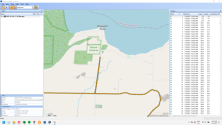
First, we'll need to move the recorded track from your device to the PC. Hook it up via USB and navigate to Android/data/net.osmand/files/tracks/rec - that's where OsmAnd stores all of your recorded tracks. Copy the .gpx file over to your PC. The one I'm doing today is called 2022-07-04_11-39_Mon.gpx

Download and install GPS Track Editor - it's free. Start GPS Track Editor and open the GPX file you copied to your PC. Here's what my Monday track looks like:
Image 2022 07 06 085306837

The left panel shows the file and all of the tracks that make it up. The right panel shows all of the points logged on this trail. There's a button on the top menu that has two opposing arrows. Click that a few times to toggle the view back and forth. The view you want shows a lot of individual arrows for each recorded point, like my screen above.

Now I'll zoom in on that little Northbound stretch at the top of the recorded trails:

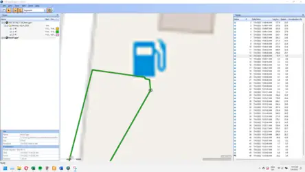
Image 2022 07 06 085849148


That's a stretch where I ran up to a convenience store and came back. Usually with GPX editing, you want to save a portion of your trip, and delete duplicate information - so for this piece I'm going to cut it out and only keep the Northbound segment, and throw out the Southbound segment that only overlaps the North anyway. Zoom in closer to see more detail:

Image 2022 07 06 090206693


Now, at the top left menu buttons make sure you've selected the black arrow that allows you to "edit points." Click a spot on the track and right-click, select restructuring -> add break. Now it looks like this:

Image 2022 07 06 090356205


I added another break at the other end, so now that stretch is isolated:

Image 2022 07 06 090534503


Now expand out the folder in the left nav, and you'll see there are three segments (because we've broken it up.) You can select the one we're working on (it's in bold,) right-click and "save as." Give it a name.

Image 2022 07 06 090854717


Now you can make it look how you want it to, then save it. In this case, I want to delete the return track heading South, and maybe square it up to the intersection. I zoom in very close to the top of the route, and you can see where I turned around. Select the point where you want to do the break, and you'll see in the left nav that I have selected point #13. That means I want to keep points 1-12, and delete the rest to have a single track.

In the right nav, click point #13 and hold SHIFT while you press DELETE. If you don't hold SHIFT down, you get a "partial deletion" which leaves behind a track that's not a track. I don't know why, or what purpose it serves, but it clutters up your data if you don't fully delete the segments using SHIFT+DELETE.

Keep deleting segments until all you're left with is points 1-13. Now all we have left is the segment we wanted to keep:

Image 2022 07 06 091958344


You can edit the track if you want to change it at all. Just click a point and drag it. When it looks like you want it to, go back to the left nav and you'll see that your track segment has an asterisk next to it (meaning there have been changes since the last save.) Save it again, and you're done.

Now you can move that .gpx file back to your nav system, and it'll be available to select and view. In OsmAnd, you're putting it in the tracks folder, one level above the rec folder we accessed earlier (Android/data/net.osmand/files/tracks)

You can view the new track segment you created in OsmAnd by going to Configure map -> Tracks. See the track with the name you gave it appears in your list, select it with the check-box, and it'll appear in OsmAnd. Image 2022 07 06 085822629 Image 2022 07 06 091356677
 
Last edited:
P1K5Dave

P1K5Dave

Well-Known Member
Lifetime Member
Club Contributor
Jul 11, 2020
2,260
8,463
113
Petoskey, MI
Ownership

  1. 1000-5
The next challenge is building collections of tracks that are grouped together. Obviously, if you just kept clipping and creating segments like we did above, your list of tracks would get long, and it probably wouldn't be useful to be able to find it and turn it on or off.

That's why I keep about a dozen categorized GPX files, and instead of saving this segment by itself, I would have added it to my "roads.gpx" file. This step is a bit more technical and requires that you download a text editor such as Notepad++. Then you'll be venturing into the world of editing raw XML data. It's not rocket science, but there are a number of steps involved.

For another day...
 
W

WRFP399

Active Member
Jul 12, 2021
54
141
33
Eagle River, AK
Ownership

  1. 1000-5
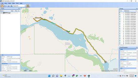
I have started my foray down this path. This trail system is heavily braided and I have not explored much of it. Knik River Public Use Area · Palmer, AK 99645

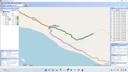
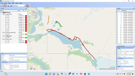
So far I have taken a few rides and had some GPX tracks saved. I opened them up and merged them. I then had the program filter the GPS pointed by distance with 25 feet being the minimum I chose. I went through a removed errors, either via GPS or obvious diversions from U-turns or other situations. I deleted the tracks that overlapped one another where the braids come back together to make it less confusing.

GPXEditor1
GPXEditor2
 
W

WRFP399

Active Member
Jul 12, 2021
54
141
33
Eagle River, AK
Ownership

  1. 1000-5
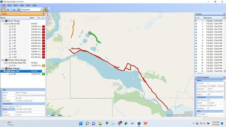
So I see that if tracks have the same date and same name, when you merge them it combines them into one. This keeps all the track segments together which is nice. I was able to take all the tracks for the Glacier trail and get them to combine except for the one from June 2021. How do I reset the date on that track so I can get it combine with the others and have one Glacier Trail track?

For those wondering, the green and orange tracks are connected via road which is visible when imported into OsmAnd.

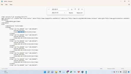
EDIT: I figured out that a way to change the dates all in one shot using Notepad allowing me to merge the Glacier Trail together. This also showed me that keeping the trails separated into separate GPX files keeps it cleaner. Merging the Maud and Rippy Trails into the Glacier trail for one large KRPUA file makes editing harder right now. Maybe once I have a "finished" product I will merge them all together into one KRPUA file.

My Original Attempt:
GPXEditor3
Separated Out:
GPXEditor4
Notepad: Using "Ctrl" + "F" for the find function.
GPXEditor5
 
Last edited:
advertisement

About us

  • Our community has been around for many years and pride ourselves on offering unbiased, critical discussion among people of all different backgrounds. We are working every day to make sure our community is one of the best.

User Menu

Buy us a beer!

  • Lots of time and money has gone into making sure the community is running the best software, best designs, and all the other bells and whistles. Care to buy us a beer? We'd really appreciate it!

    Beer Fund!

    Club Membership!