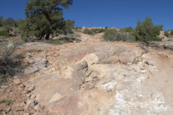
Southeast Utah - Comb Ridge

Durangotang

Durangotang

Active Member
Feb 24, 2018
43
216
33
Just outside Durango, CO
The weather is getting nice so went camping and riding in a spot in SE Utah known as Comb ridge:

From the interweb: Comb Ridge (Navajo: Tséyíkʼáán) is a linear north to south-trending monocline nearly 80 miles long in southeast Utah and northeast Arizona. Its northern end merges with the Abajo Mountains some eleven miles west of Blanding.

We camped just west of the ridge in Comb Wash (a BLM open camping area) off UT Hwy 95 to the west of Blanding, UT. Rode around the immediate area checking out the trails and some prehistoric Native American dwellings.

Here's a shot from the top of the ridge looking south at Hwy 95. In the wash below you can see the open BLM camping area.
DSC 0032


Yup, there's our campsite.
DSC 0026

Here's the view looking to the north.
DSC 0040

So how do you get from the wash to the top of the ridge? One way is to take the original "highway". It's the shelf road cut diagonally across the sandstone rock face in the photo below.
DSC 0063


Here's the upper part where it breaches the edge of the ridge.
DSC 0060

Looking back down.
DSC 0062

Another trail on the west side of the wash. Lots of slick rock in the area.
DSC 0101

DSC 0095 DSC 0097
Besides some excellent trails there's also Native ruins everywhere!
DSC 0068

Along with petroglyphs.
DSC 0080


It would take weeks to explore this area. So we'll be back.
 
100Acre

100Acre

Samsquinch the Terrible Magic Bean Manipulator
Lifetime Member
Club Contributor
Apr 25, 2017
17,360
103,362
113
Idaho
Ownership

  1. 1000-5
DUDE, BADASS!!! Thats been on my bucket list for sometime. Great to see some pix. Thanks for sharing that.
 
  • Like
Reactions: Mudwing
Montecresto

Montecresto

Montecresto el segundo
Lifetime Member
Supporting Member
Club Contributor
Jan 17, 2016
22,587
34,173
113
Eastern oklahoma
Ownership

  1. Other Brand

  2. 500

  3. 1000-3

  4. 1000-5

  5. Talon X4
The weather is getting nice so went camping and riding in a spot in SE Utah known as Comb ridge:

From the interweb: Comb Ridge (Navajo: Tséyíkʼáán) is a linear north to south-trending monocline nearly 80 miles long in southeast Utah and northeast Arizona. Its northern end merges with the Abajo Mountains some eleven miles west of Blanding.

We camped just west of the ridge in Comb Wash (a BLM open camping area) off UT Hwy 95 to the west of Blanding, UT. Rode around the immediate area checking out the trails and some prehistoric Native American dwellings.

Here's a shot from the top of the ridge looking south at Hwy 95. In the wash below you can see the open BLM camping area.
View attachment 124643

Yup, there's our campsite.
View attachment 124642
Here's the view looking to the north.
View attachment 124644
So how do you get from the wash to the top of the ridge? One way is to take the original "highway". It's the shelf road cut diagonally across the sandstone rock face in the photo below.
View attachment 124647

Here's the upper part where it breaches the edge of the ridge.
View attachment 124645
Looking back down.
View attachment 124646
Another trail on the west side of the wash. Lots of slick rock in the area.
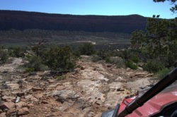
View attachment 124652
View attachment 124650 View attachment 124651
Besides some excellent trails there's also Native ruins everywhere!
View attachment 124648
Along with petroglyphs.
View attachment 124649

It would take weeks to explore this area. So we'll be back.
Love that!!! :cool:
 
100Acre

100Acre

Samsquinch the Terrible Magic Bean Manipulator
Lifetime Member
Club Contributor
Apr 25, 2017
17,360
103,362
113
Idaho
Ownership

  1. 1000-5
Is this the same as the Cockscomb road? If so, I’m thinking about doing it on this trip. Anything I need to know?
 
100Acre

100Acre

Samsquinch the Terrible Magic Bean Manipulator
Lifetime Member
Club Contributor
Apr 25, 2017
17,360
103,362
113
Idaho
Ownership

  1. 1000-5
This looks like it the same ride maybe? This guy does it in a full size pickup. Definitely some pucker effect moments. Thinking I may hit this trail and others before the Taylor Park ride in September. I drove right by this trail February last year. Right by it! Dang!
 
Montecresto

Montecresto

Montecresto el segundo
Lifetime Member
Supporting Member
Club Contributor
Jan 17, 2016
22,587
34,173
113
Eastern oklahoma
Ownership

  1. Other Brand

  2. 500

  3. 1000-3

  4. 1000-5

  5. Talon X4
Reminds me of the “shelf road” to Cripple Creek. :eek:
 
Durangotang

Durangotang

Active Member
Feb 24, 2018
43
216
33
Just outside Durango, CO
That video is the route (Google shows it as 229) we took up the side of Comb Ridge. Posey Trail actually runs along the top of the ridge from north to south. We encountered several Jeeps on it that afternoon but I was happy to have the 50" narrow width to give me more options in picking over the rocks.
 
  • Like
Reactions: 100Acre

About us

  • Our community has been around for many years and pride ourselves on offering unbiased, critical discussion among people of all different backgrounds. We are working every day to make sure our community is one of the best.

User Menu

Buy us a beer!

  • Lots of time and money has gone into making sure the community is running the best software, best designs, and all the other bells and whistles. Care to buy us a beer? We'd really appreciate it!

    Beer Fund!

    Club Membership!