GPS Purchase

joeymt33

joeymt33

i4WD=imitated 4WD
Moderator
Lifetime Member
Supporting Member
Club Contributor
Mar 17, 2015
11,092
39,079
113
Guntersville, AL
Ownership

  1. 1000-3

  2. 1000-5
I hope I don't get in trouble for mentioning this but has anyone tried the Ride Command app?

It's a free download and I just got it. I hope to try it out soon. I like that it will track everyone in your group and show them on the map. I have an old iPhone 6 permanently mounted and hope to find some app that will save some money vs buying a gps.
 
  • Like
Reactions: sharp, lee and JTW
J

JTW

Guest
I hope I don't get in trouble for mentioning this but has anyone tried the Ride Command app?

It's a free download and I just got it. I hope to try it out soon. I like that it will track everyone in your group and show them on the map. I have an old iPhone 6 permanently mounted and hope to find some app that will save some money vs buying a gps.
Oh s***.. you're in trouble now!
 
ohanacreek

ohanacreek

My EcoBoost has I4WD
Moderator
Lifetime Member
Jul 25, 2013
11,346
32,045
113
Shelby County, Alabama
Ownership

  1. 1000-5
I hope I don't get in trouble for mentioning this but has anyone tried the Ride Command app?

It's a free download and I just got it. I hope to try it out soon. I like that it will track everyone in your group and show them on the map. I have an old iPhone 6 permanently mounted and hope to find some app that will save some money vs buying a gps.

Had it but the user added trails were horrible. I'll have to see if they've gotten any better.
 
  • Like
Reactions: joeymt33 and JTW
sugarray

sugarray

Is this a game show?
Lifetime Member
Feb 17, 2016
661
1,257
93
WV
Ownership

  1. 1000-5
What app are folks running apple using? I have an old Garmin nuvi somewhere, if I can find it. I think
I can add maps into.


Using OnX Hunt right now, but haven't ran a track yet. It worked a week ago when I didn't have phone service on the downloaded map
 
  • Like
Reactions: sharp and JTW
stevenj

stevenj

Member
Sep 14, 2015
41
54
18
I use my LG 8" tablet with Orux Maps and Backcountry Navigator apps. Works great for my needs.
 
  • Like
Reactions: sharp
sugarray

sugarray

Is this a game show?
Lifetime Member
Feb 17, 2016
661
1,257
93
WV
Ownership

  1. 1000-5
I use my LG 8" tablet with Orux Maps and Backcountry Navigator apps. Works great for my needs.

Are you using GPS or cellular service?
 
  • Like
Reactions: sharp
RobbieS

RobbieS

Active Member
Nov 26, 2016
78
163
33
Pagosa Springs, Colorado
Ownership

  1. 500
I use a Garmin Map 78SC. It's waterproof and floats. It Ram mounts in the P5 and also onto the deck of the kayak. Fits nice on the side of the hunting pack. I've beaten it and it keeps running. I mainly use it to lay out a breadcrumb trail of where I've been. Haven't been lost since I bought it!

With any Garmin you can lay out a track on Google Earth then import it in the GPS.
Al

Can you guide me to a source for details on how to add the track from Google Earth to my Garmin?
 
AlR

AlR

Well-Known Member
Nov 14, 2016
470
1,166
93
Nanaimo, British Columbia
Ownership

  1. 500
Can you guide me to a source for details on how to add the track from Google Earth to my Garmin?
I looked at the link in post #28. That's not what I do. So here is how I create a track on GoogleEarth and transpose it into Garmin BaseCamp / onto your Garmin GPS:

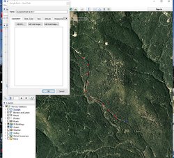
Go to Google Earth. Hopefully we have similar versions. I'm doing this on a desk top computer.
- go to 'Add', 'Path'
- name your path ("Awesome track to try")
- move your cursor onto the GoogleEarth map and you'll have a square looking cursor.
- use that square cursor to tap / plot out the path you want.
[PS: some of these images are small. Just double-click on them. Best viewed on your desktop].

GoogleeEarth You can kinda see the path I started in the middle of the image.
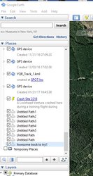
- once you have plotted out a chunk of your path, hit 'ok'. The track will appear in your GoogleEarth at the left side...

Ge2 In this image you can see the track I saved.
- ensure your 'awesome track to try' is highlighted. Next go 'file', 'save', 'save place as'
- save the track into some directory in your computer
- now open Garmin BaseCamp. Go 'file', 'import into my collection' or 'import into my device'
- go to where you stored your GoogleEarth path and click it. That path will now import into your Garmin Basecamp directory.

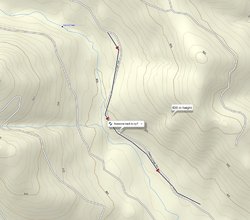
Ge3
You can see 'Awesome track to try' in the Garmin basecamp directory.
From there you can drag and drop that track into your Garmin GPS.

Ge4 Here you can see the path that you created on GoogleEarth, now showing up as a track on your GPS.
Seems like alot of work, but once you get the hang of it, it's easy. In your Garmin device, you can convert the 'track' into a 'route'. You can add tracks / routes together into a long string. In the maze of logging roads that I travel, I like setting up routes if I wanna go somewhere specific. To further confuse you, you can export a track from Garmin Basecamp into GoogleEarth.

Hope this didn't confuse you (and that we have the same versions of the software etc).
FYI
Al
 
Last edited:
  • Like
Reactions: ohanacreek
RobbieS

RobbieS

Active Member
Nov 26, 2016
78
163
33
Pagosa Springs, Colorado
Ownership

  1. 500
I looked at the link in post #28. That's not what I do. So here is how I create a track on GoogleEarth and transpose it into Garmin BaseCamp / onto your Garmin GPS:

Go to Google Earth. Hopefully we have similar versions. I'm doing this on a desk top computer.
- go to 'Add', 'Path'
- name your path ("Awesome track to try")
- move your cursor onto the GoogleEarth map and you'll have a square looking cursor.
- use that square cursor to tap / plot out the path you want.
[PS: some of these images are small. Just double-click on them. Best viewed on your desktop].

View attachment 37322 You can kinda see the path I started in the middle of the image.
- once you have plotted out a chunk of your path, hit 'ok'. The track will appear in your GoogleEarth at the left side...

View attachment 37324 In this image you can see the track I saved.
- ensure your 'awesome track to try' is highlighted. Next go 'file', 'save', 'save place as'
- save the track into some directory in your computer
- now open Garmin BaseCamp. Go 'file', 'import into my collection' or 'import into my device'
- go to where you stored your GoogleEarth path and click it. That path will now import into your Garmin Basecamp directory.

View attachment 37325 You can see 'Awesome track to try' in the Garmin basecamp directory.


From there you can drag and drop that track into your Garmin GPS.

View attachment 37326 Here you can see the path that you created on GoogleEarth, now showing up as a track on your GPS.
Seems like alot of work, but once you get the hang of it, it's easy. In your Garmin device, you can convert the 'track' into a 'route'. You can add tracks / routes together into a long string. In the maze of logging roads that I travel, I like setting up routes if I wanna go somewhere specific. To further confuse you, you can export a track from Garmin Basecamp into GoogleEarth.

Hope this didn't confuse you (and that we have the same versions of the software etc).
FYI
Al

Thank you, that is great information!!
 
  • Like
Reactions: AlR
advertisement
stevenj

stevenj

Member
Sep 14, 2015
41
54
18
Are you using GPS or cellular service?

It's both just like your phone. Cellular service to download the map of the specific area and GPS to show your location. However if you think cell service is limited where you will be riding you can download a specific area of maps so you have it regardless of cell service. It's a really big file depending on how big of area so only get what you need.
 
  • Like
Reactions: JTW
nbomar

nbomar

Well-Known Member
Lifetime Member
Oct 11, 2015
4,416
17,854
113
Springdale, AR
Ownership

  1. 1000-5
I hope I don't get in trouble for mentioning this but has anyone tried the Ride Command app?

It's a free download and I just got it. I hope to try it out soon. I like that it will track everyone in your group and show them on the map. I have an old iPhone 6 permanently mounted and hope to find some app that will save some money vs buying a gps.

I've had it since it came out. It's getting better. It was crap at first. I will say whoever Polaris is using for this software is updating it like crazy. Bravo for that. They update usually every week if not several times a week. I haven't used it in the past few weekends. It's noticeable better every time I've tried it.


Sent from my iPhone using Tapatalk
 

About us

  • Our community has been around for many years and pride ourselves on offering unbiased, critical discussion among people of all different backgrounds. We are working every day to make sure our community is one of the best.

User Menu

Buy us a beer!

  • Lots of time and money has gone into making sure the community is running the best software, best designs, and all the other bells and whistles. Care to buy us a beer? We'd really appreciate it!

    Beer Fund!

    Club Membership!