P1000 Off road navigation

knuckledeep

knuckledeep

my trailer queen is trashy
Lifetime Member
Dec 16, 2015
1,052
3,470
113
Eustis florida
Ownership

  1. 1000-3
  • I am wondering what off road gps or navigation system.people are using we want to do bigger trails and go places we haven't been before. Let me know what you all are using.
 
  • Like
Reactions: sharp
J

jfreak

New Member
Jul 25, 2016
10
10
3
PNW
Ownership

  1. 1000-5
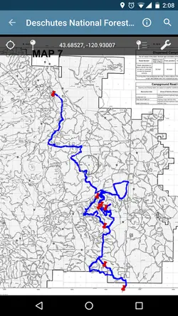
I use my smart phone or tablet with avenza PDF maps app
 
  • Like
Reactions: sharp
AKRider

AKRider

Well-Known Member
Lifetime Member
Supporting Member
Club Contributor
Mar 31, 2016
1,402
3,224
113
Palmer, Alaska
Ownership

  1. 1000-5
Get a good GPS. Cell phones don't always have coverage, especially where I go. Also, check out www.huntinggpsmaps.com. These are detailed maps with boundaries, land ownership, trails, etc. Pretty sure they are only for Garmin. They also have maps that can be used in their Basecamp software to use as a planning tool.
 
X4Dice

X4Dice

Active Member
Jun 3, 2016
87
130
33
USA
Ownership

  1. 500

  2. 1000-3
I have OnXmaps for my GPS as well and love it.
 
  • Like
Reactions: AKRider
J

jfreak

New Member
Jul 25, 2016
10
10
3
PNW
Ownership

  1. 1000-5
That's the beauty of avenza and smartphones. Most smartphones have GPS built in, where I go there's no service for 20+ miles and I've never had a problem finding my way home.

Its just a good cheap alternative to a full off-road GPS. Obviously I'd love to have a lowrance or the like... But a free app that has yet to let me down will suffice

You can track where you go, pin points of interest with pictures... Here's a screenshot Screenshot 20161218 140821 zpsmfnxuliy
 
Last edited:
  • Like
Reactions: Delton
AKRider

AKRider

Well-Known Member
Lifetime Member
Supporting Member
Club Contributor
Mar 31, 2016
1,402
3,224
113
Palmer, Alaska
Ownership

  1. 1000-5
That's the beauty of avenza and smartphones. Most smartphones have GPS built in, where I go there's no service for 20+ miles and I've never had a problem finding my way home.

Its just a good cheap alternative to a full off-road GPS. Obviously I'd love to have a lowrance or the like... But a free app that has yet to let me down will suffice
I've been in places here where even a good GPS sometimes has a hard time acquiring satellites. The only thing my phone is good for in those places is as an alarm clock.
 
advertisement
Hrdman

Hrdman

New Member
Sep 21, 2016
11
9
3
85122
Ownership

  1. 1000-5
I use a Magellan TRX7 which so far has served me well. It is big enough to keep an eye on while driving. Where I am in south AZ cell service is nonexistent where I do most of my riding. A bit hard to see in direct sun light but certainly does the job and saved my ass a few times.
 
  • Like
Reactions: sharp and AKRider
Delton

Delton

Honda Fanboy
Vendor
Lifetime Member
Club Contributor
Jan 6, 2016
9,967
31,488
113
Middle TN
Ownership

  1. 1000-5
I use a Garmin 64st. Actually just ordered my switch plate for my sxs so that I can mount it on the dash.
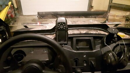
Be sure and post a pic of that install. Betting that is gonna look pretty sweet
 
  • Like
Reactions: sharp
AlR

AlR

Well-Known Member
Nov 14, 2016
470
1,166
93
Nanaimo, British Columbia
Ownership

  1. 500
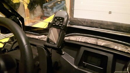
I use a Garmin GPSmap 78S. I have the RAM mount cradle for it and the 12 volt cord. It is securely fastened to the dash.

20161219 050431 resized

I use the 78S for kayaking and hunting/ hiking as well. It's waterproof and actually floats. It's sat on the handlebar of my ATV for several thousand kilometers and hasn't been affected by the shaking and pounding it gets. I've used it at -25C on a bison hunt up north and it functions fine after being immersed in ocean water. It'll pick up the gps signal in my pocket or backpack.

20161219 050443 resized

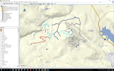
It has a variety of screen functions but I generally leave it on the breadcrumb screen so I can see where I've been and how I can get back to the truck. I have the topographic map chip for N. America and it shows alot of the trails. Using Garmin BaseCamp on your home computer (a free download) you can transfer your day's track to the computer; save it, edit it and send it to friend or other blog dogs.

20161219 basecamp shot

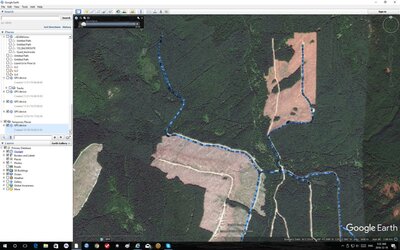
You can lay that track onto Google Earth and see your track on the aerial image. In this image, I imported a GPS track into Google Earth. You can also use Google Earth to plot out tracks following roads, then export to the Garmin.

20161219 googleearth shot

UPDATE: April 2019. Three more years of use and another couple of thousand kms of pounding and the unit is still running fine.

I appreciate that guys use their cell phones to do this stuff. My cell would never handle the abuse I'd give it and I dislike getting lost. I never worry about going in to new or unfamiliar areas.
Al
 
Last edited:
Alan aka Davinci

Alan aka Davinci

Mr. Meme Master
Lifetime Member
Apr 25, 2015
16,790
183,384
113
Grand Junction, CO
Ownership

  1. 500
I have OnXmaps for my GPS as well and love it.
I agree on the OnXmaps. I have used every type of map made from paper to digital over the years and OnXmaps is by far the best you can get without being accused of being a Russian spy.
 
Last edited:
  • Like
Reactions: AKRider and X4Dice

About us

  • Our community has been around for many years and pride ourselves on offering unbiased, critical discussion among people of all different backgrounds. We are working every day to make sure our community is one of the best.

User Menu

Buy us a beer!

  • Lots of time and money has gone into making sure the community is running the best software, best designs, and all the other bells and whistles. Care to buy us a beer? We'd really appreciate it!

    Beer Fund!

    Club Membership!